An update from PhD researcher Gerard!
This is Gerard here. My first few months of research have been gaining an understanding of the pre-existing literature and processing a complete set of multibeam data that we collected in Cork Harbour.
My PhD is focused on determining the processes that control seabed habitats using new approaches designed to increase the precision of habitat mapping studies. Such techniques are important to monitoring areas that have been designated for conservational purposes. Our other objective is to ensure that these techniques can be used to help identify similar areas of conservational interest and help in their preservation. As an avid geologist and a conservationist, I am very pleased to do my part in helping Ireland achieve its goals for the EU Marine Habitats Directive and work on the cutting edge of geological research. Cork Harbour provides an ideal training ground for the development of techniques that will assist us in unravelling this mystery. I think it’s important to give a brief background to the multibeam data the techniques included in its processing, and how it provides a comprehensive dataset of the seafloor.
Multibeam sonar technology involves sending sonar beams out and recording the return signal, much like that of a bat, whale, or dolphin. Multibeam sonar produces this sound as a series of cones that are narrow front to back and is wide at the sides. A three-dimensional image of the floor is created when the ship that the multibeam device is attached to moves. We can harvest 3 types of data from this approach, the most widely studied is bathymetry, this focuses on the depth of the seafloor and is a measure of the speed of sound through water and the return time of the emitted sonar pulse. This data has been refined to a resolution that matches the definition of most satellite and aerial photography. Bathymetry can be used as dataset from which we can extract information, like what direction the seafloor features are facing, what depth do certain fauna occur at, providing data on the size of structures on the seafloor, and it can act as a baseline dataset for other information collected during a marine survey.
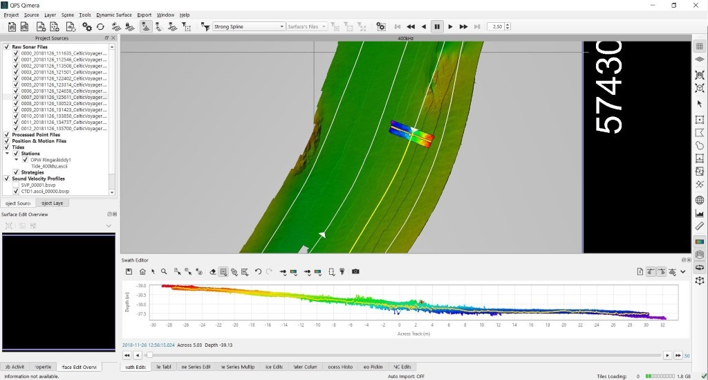
Figure 1: An example of real time bathymetric data from Cork Harbour being processed
Multibeam Backscatter is an interesting field of research and one that has remained quite enigmatic as initially it was a lower level of priority than bathymetry, and as such did not receive the same amount of attention when discussing seafloor habitats. However, this has since changed, and backscatter has now become one of the cornerstones of seabed habitat mapping. Backscatter data measures the return strength of the sound signal and applies a value to it. This strength value is a product of a complex series of processing algorithms that are designed to take any interference introduced to the data from the position of the multibeam in the water and the change of the properties of the water column itself. We can deduce seafloor coverage changes from this data, which can be combined with other data sets such as grab samples of the seafloor and video data to link the backscatter values with actual geological data. Most research has been done with backscatter datasets that have been acquired with a single frequency of sound. It has been shown in the past that this data can change with a resultant change in the frequency emitted by the sonar device. Our research will focus on using different acoustic frequencies to deduce how these changes in backscatter data connect with the sediment, this technique has originated from satellite imagery processing, where different frequencies of light provide information about the land cover. We create images that show the different sound frequencies as different colour, this is called false colour imaging, and this helps highlight areas where frequencies differ in their backscatter response.
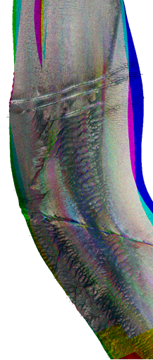
Figure 2: Example of multifrequency backscatter from Cork Harbour, displaying 200 kHz (red), 300 kHz (green), and 400 kHz (blue). Purples, yellows, whites, greys, and turquoises represent areas that show reflect of 2 or more frequencies.
The third and final multibeam dataset is the water column data. Like multifrequency backscatter, water column data is a fresh avenue for seabed habitat mapping researchers and provides further insight into one of the key parameters of the marine habitat and that is the water itself. The multibeam records the backscatter response at set intervals of distance and creates a cone shaped view of the water column. With this data we can map the structure of the water column; the properties, different water masses, etc.; the flow of the water, suspended particles, and potential biota that live in these areas. With our research we want to take this one step further and map the water column at different frequencies, with this we hope to show that this data will change with the emitted frequency, enhancing the dataset for marine habitat mappers. This is an area that I am particularly excited about and I hope to bring new ideas to this facet of habitat mapping.
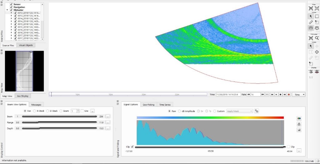
Figure 3: Water column data from Cork Harbour[/caption]
Other information that supplements much of the multibeam data includes video surveys of the seafloor, sediment sampling, and CTD casts. These datasets link multibeam values such as backscatter and water column data with real environmental parameters and are crucial when uncovering the mechanisms of seafloor processes. As such we have acquired a drop camera system that will allow us to take high definition georeferenced photos of the seafloor and the associated fauna and this will allow us to match the multibeam with sediment characteristics and with the seabed faunal assemblages. CTD casts allow us to map the properties of the water column itself, this informs the multibeam data about the properties that will affect the speed of sound through the water, allowing it to correct for any alterations in the data because of this. It also provides data about the water masses and how they change vertically through the seafloor.
Currently, I have corrected the backscatter to show the real seafloor image and I am eliminating errors in the bathymetric dataset with the goal of combining these 2 datasets and investigate how they interact. With the ultimate ambition of providing an efficient, repeatable technique for incorporating all the stages of multibeam investigations.
This is a voyage of scientific discovery that I am very privileged to undergo and share every step of my journey with you all.
Marine Geosciences Research Group
University College Cork
Contact us
School of Biological, Earth and Environmental Sciences, North Mall Campus, University College Cork, North Mall, Cork City, T23 TK30