Summary
Novel Mapping Of The Shallow Water INFOMAR Data Set: Towards Irelands First Shallow Water Atlas (NoMans_TIF)
Since 1996, Ireland has undertaken one of the most ambitious seabed mapping programme in the world. Thanks to the Irish National Seabed Survey (INSS 2003-2006) and INFOMAR programmes (2006-2026), to date over 700,000 km² (80%) of the seafloor within the Irish designated area has been surveyed in high resolution. While a great deal of work has been already achieved, the quality of the data and modern mapping techniques now offer a significant opportunity to develop a standard Irish mapping approach, and the most detailed and comprehensive geomorphological map of the Irish continental shelf (NOMANS_TIF). The outcome of this work has the potential to benefit policy makers and industry (e.g. offshore renewables, marine spatial planning) as well as raising awareness of the marine environment to the tax payer.
We propose to test a number of existing GIS-based mapping tools in order to determine and develop a suitable geomorphic mapping protocol for the vast Irish shallow water area. Due to the shear amount of data, particular focus will be given to semi-automated and automated segmentation and classification approaches, also testing the hermeneutic limits of modern machine-based mapping in geomorphology (given that geomorphometric descriptors will be ultimately insufficient to define a landform in a full geomorphological sense). The key outcomes of NOMANS_TIF will be the development of GIS layers and a shallow water Atlas of the Irish Quaternary and Holocene geomorphology, highlighting key seabed features in shallow Irish waters (<200 m). All the products will be freely available and integrated within the INFOMAR and the Irish Marine Atlas, for the benefit of future marine scientist, governmental agencies, industry and the general public.
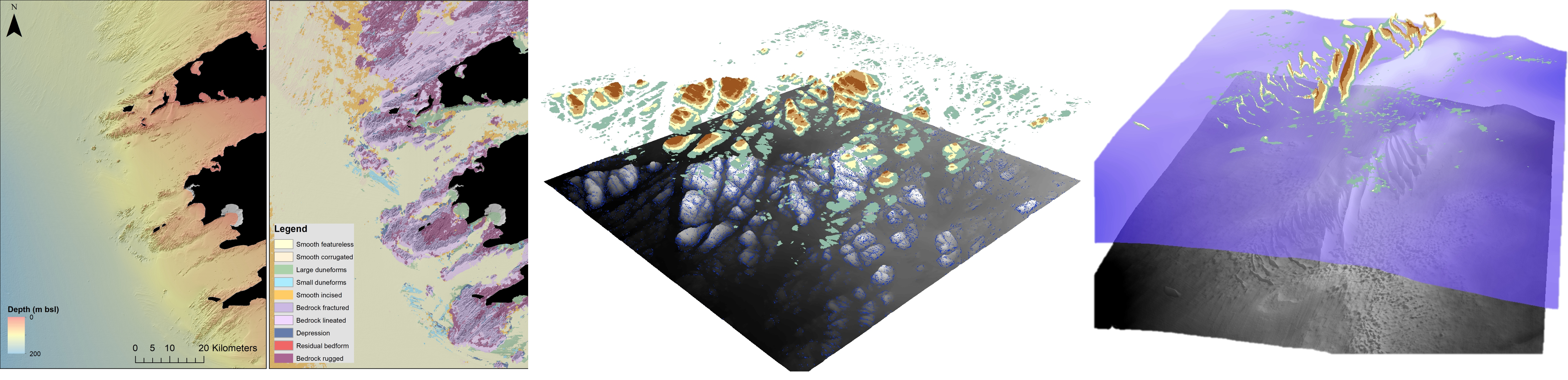
Left to right: Fully convolutional predictions are for the Kerry coast; removal filtering applied on the seabed to extract bedrock (detrending + fill sink algorithm) and sandwaves (rolling ball filter).
Aims
1: collate the datasets already collected by INFOMAR, combine this with data from existing studies and create a geomorphological map of the features on the Irish shelf (<200m bsl)
2: The development of techniques to map large datasets, especially in areas where ground-truthing is scarce. This will involve automated feature detection and the designation of ‘potential’ habitats
3: To produce an atlas of seabed features that can be used by a range of stakeholders to benefit the marine sector in Ireland, as well as on an international scale.
Contributors
Dr Riccardo Arosio (Postdoctoral Fellow)
Prof. Andy Wheeler (PI)
Dr. Fabio Sacchetti (Marine Institute collaborator)
Dr. Luis Conti (collaborator)
Dr. Aaron Lim (collaborator)
Funded By
Marine Geosciences Research Group
University College Cork
Contact us
School of Biological, Earth and Environmental Sciences, North Mall Campus, University College Cork, North Mall, Cork City, T23 TK30