Irish Shelf Seabed Geomorphological Map (v2023)
The Marine Geoscience group at UCC and the Marine Institute present the Irish Shelf Seabed Geomorphological Map, the first high-resolution geomorphological map of the entire Irish continental shelf. Explore it HERE!
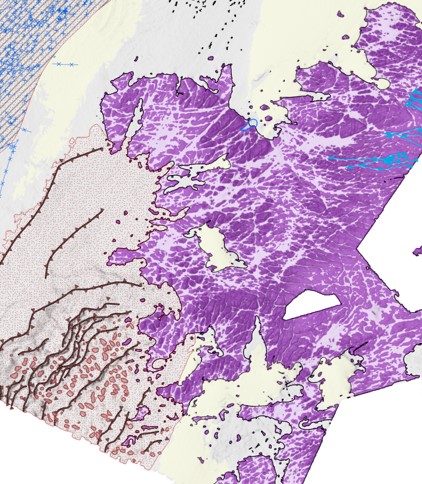
The map is the first high-resolution (up to 10 m/ pixel) geomorphological map of the entire Irish continental shelf, down to a depth of 200 metres below sea level (Arosio et al., submitted). This large-scale mapping exercise, funded by the Marine Institute, took advantage of the vast INFOMAR multibeam echosounder dataset, and used a protocol of semi-automated mapping techniques to accurately and rapidly extract seabed features. All previous mapping efforts and existing literature on the Irish shallow shelf geomorphology have been collated and integrated in the map, re-delineating features using the machine-assisted techniques and critically evaluating the previous interpretations. An internationally standardised terminology and classification scheme for geomorphology was adapted from the collaboration between Mareano-INFOMAR-Maremap and Geoscience Australia (MIM-GA), aligning the Irish Shelf Seabed Geomorphological Map (v2023) to other international geomorphological work. Details on the scheme can be found in Dove et al. (2020) and Nanson et al. (2023).
The map includes both newly identified and re-assessed seabed morphological and geomorphological units (e.g. channels, drumlins, dunes etc.) and the different types of substrate (e.g. bedrock, unconsolidated or consolidated superficial deposits) that have been mapped to represent the dominant composition of the top two metres of the seafloor. Classification and attributes for each feature are contained within the attribute table accompanying each vector file of the map. The ISSGM (v2023) includes three additional attributes not existing in the MIM-GA scheme, which are applied to further describe geomorphic units (Arosio et al., submitted). Map shapefiles have been uploaded to the Irish Marine Data Centre and can be found here.
At a national level, this detailed geomorphological digital map is intended primarily as a resource to better inform multiple offshore activities and management of the marine environment on the Irish continental shelf. The information contained is of importance to a range of stakeholders connected to offshore fisheries, aquaculture, renewable energy (wind, wave and tidal power), seabed cables for communications and power, dredging and the aggregate industry. The map also acts as a baseline for future studies in marine geomorphology, as it identifies gaps in the knowledge and highlights areas of contentious interpretation that require further work.
References
Arosio, R., Wheeler, A.J., Sacchetti, F., Guinan, J., Benetti, S., O’Keeffe, E., Van Landeghem, K.J.J., Conti, L.A., Furey, T., and A. Lim. The geomorphology of Ireland’s continental shelf, Journal of Maps, (submitted)
Dove, D., Nanson, R., Bjarnadóttir, L.R., Guinan, J., Gafeira, J., Post, A., Dolan, M.F.J., Stewart, H.A., Arosio, R., Scott, G., 2020. A two-part seabed geomorphology classification scheme (v.2); Part 1: morphology features glossary. Zenodo. https://doi.org/10.5281/ZENODO.4075248
Nanson, R., Arosio, R., Gafeira, J., McNeil, M., Dove, D., Bjarnadóttir, L., Dolan, M., Guinan, J., Post, A., Webb, J., Nichol, S., 2023. A two-part seabed geomorphology classification scheme; Part 2: Geomorphology classification framework and glossary (Version 1.0). Zenodo. https://doi.org/10.5281/zenodo.7804019
For more on this story contact:
Riccardo Arosio (rarosio@ucc.ie)
Marine Geosciences Research Group
University College Cork
Contact us
School of Biological, Earth and Environmental Sciences, North Mall Campus, University College Cork, North Mall, Cork City, T23 TK30