Digital Environmental Technology for Enhanced Coastal Zone Management (DETECT)
Using advanced technologies to help Irish communities understand climate risks at vulnerable coastal sites around Ireland
The Challenge
With sea levels rising and storms increasing in frequency and severity, many coastal regions globally are facing growing pressures from climate related hazards. Ireland is no exception, with numerous coastal communities struggling to cope with flooding and erosion induced by storms. These hazards can have far-reaching consequences, disrupting economic activity, damaging vital infrastructure, degrading coastal ecosystems, and permanently altering sites of cultural and recreational significance. Mitigating and managing these hazards requires an in-depth understanding of not only why these hazards occur, but where they occur, and what and who is most at risk.
Traditional approaches for reducing coastal risk often rely on hard, engineered structures, such as seawalls or rock armour. Although vital in certain areas, these often prove to be short-term, costly solutions. In contrast, coastal habitats can serve as effective natural buffers from storms and provide a more sustainable, nature-based solution for coastal protection, offering numerous environmental, economic, and social benefits.
By mapping the relative exposure to coastal hazards around Ireland, our research aims to identify at-risk coastal regions. By highlighting where habitats reduce exposure, this study also demonstrates where nature-based solutions for coastal protection are most warranted. In doing so, this research aims to support UN Sustainable Development Goal (SDG) 11 – Sustainable Cities and Communities; 13 – Climate Action; 14 – Life Below Water; and 15 – Life on Land.
The Research
Our research developed Ireland’s first national-scale Coastal Exposure Index (CEI) designed to support coastal communities, policymakers, and managers in understanding and responding to climate‑related coastal risk. The entire coastline of the Republic of Ireland was assessed at 250 m intervals, with each coastal segment ranked from “Very Low” to “Very High” exposure, allowing for direct comparison across regions and Local Authorities. The exposure values integrate locally specific physical, climatic, and socio-economic elements enabling national level assessments of people, infrastructure and heritage along the coast.
; Maharees Peninsula, Co. Kerry (Map B) and Courtown, Co. Wexford (Map C)")
The index identifies the protective role of coastal habitats highlighting where ecosystems such as dunes and saltmarshes are already reducing exposure. Importantly, we have identified where people and sites of cultural heritage are currently located within exposure “hotspots”. This makes climate risk visible in both social and physical contexts. To ensure impact, our results were packaged together at a Local Authority level to ensure findings support decisions of resource allocation and prioritisation.
The first of its kind, this research provides an accessible and transparent resource that is already being used to support evidence‑based discussion around coastal resilience, adaptation planning, and nature‑based solutions.
The research continues through UCC’s DETECT Project. Some of Irelands most exposed sites are now being monitored using repeated Unmanned Aerial Vehicle (UAV) surveys, tracking rates of coastal change to support modelling of how these environments may respond under future climate scenarios. This has involved direct collaboration with government bodies, such as the Clare County Council, the Office of Public Works (OPW), National Parks and Wildlife Services, Geological Survey, Ireland and the EPA. We also work with community based organisations, including the Burren Beo Trust and the Seafield Conservation Forum, to gain local expertise and align shared goals for conservation and management of vulnerable coastal ecosystems.
The Impact
Knowledge Production
A key output of this project is the development of the CEI, a national scale assessment designed to support understanding of climate‑related coastal risk across Ireland. As a national scale assessment, this project is relevant to a range of stakeholders particularly policy makers at the Department of Housing, Local Government and Heritage and coastal managers within the Office of Public Works, who cite the need for more research on coastal nature-based solutions in the 2023 National Coastal Change Management Strategy report. Our CEI provides ample evidence in this regard, revealing where investment in sustainable, coastal protection should be explored.
The underpinning research for the CEI is now under consideration for publication in the international open-access journal Natural Hazards. The findings have also been presented to the research community at large international conferences (IAG New Zealand), EU research training programmes and national workshops, supporting knowledge exchange across academic and applied policy audiences. These activities have increased the visibility of the research and strengthened engagement with national and international research institutions, aligning with UCC’s Strategic Goals 3.1 and 3.2.
Capacity Building Impacts
Communication of the CEI has deliberately extended beyond academic audiences to engage members of the public, practitioners, and community organisations. This public engagement was evident following publication of a research‑informed article on RTÉ Brainstorm and an opinion piece in The Irish Times (online), both of which generated significant public interest. This has developed into discussions with business owners, school teachers, and community-led nature restoration groups whom expressed concern with the rates of coastal change seen in their areas. This has reinforced the confidence in our findings and has initiated ongoing dialogue around sustainable, nature‑based coastal protection, contributing to SDGs 11 and 14 and supporting UCC’s Strategic Goal 5.1.
Upon publication of the CEI, an online interactive map will be released, enabling users to view, access, and download the results and the open‑source data which form the foundation of this assessment. By having this research in a user-friendly and easily comprehensible format, we hope to contribute to UCC’s Strategic Goal 1.4.
Environmental Impacts
Our research to date has highlighted the many challenges currently facing our nation's coastline. We have showcased not only where the effects of sea-level rise and increased storminess are having a significant impact today, but also revealed where may be severely impacted in the coming decades. This could have significant implications in terms of conservation of vulnerable sites, but could also aide in de-risking site selection of future coastal infrastructural projects, with potentially large financial and environmental benefits.
Through our engagement with community conservation groups, we aim to increase the collaboration between academia and Civil Society Organisations and demonstrate how collective action approaches can build resilient coastal communities, supporting SDG 11.
At its core, the goal of the DETECT project is to develop methodologies for monitoring and managing climate-related impacts on coastal regions and ultimately we hope to contribute to the realisation of SDG 13 by underscoring the urgent need for positive climate action at an international, national and local level.

For More Information
The project website for DETECT can be found here.
Project team webpages are also available for the Principal Investigator Aaron Lim and project PhD student Kevin Walsh. Kevin’s LinkedIn profile can be found here and ORCID profile here.
“Coastal change is no longer a distant issue for many communities in Ireland. Through DETECT, we set out to make climate risk visible in a way that supports better decisions by policymakers, practitioners, and communities alike. By combining national‑scale data with local knowledge, this project shows how evidence‑based, collaborative approaches can help protect both people and coastal environments in a changing climate.”
– Aaron Lim, Senior Lecturer in Marine Geosciences
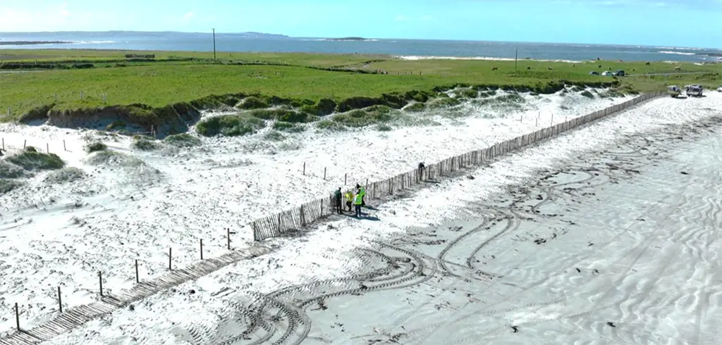
Banner Image:
Installing Chestnut fencing at Seafield Beach, Co. Clare, a highly exposed site identified during our research. Image captured in April 2026 whilst assisting the Seafield Conservation Forum, a community-led group focused on dune restoration and conservation.
College of Arts, Celtic Studies & Social Sciences
Coláiste na nEalaíon, an Léinn Cheiltigh agus na nEolaíochtaí Sóisialta
Contact us
College Office, Room G31 ,Ground Floor, Block B, O'Rahilly Building, UCC