Dr Riccardo Arosio ponders on some considerations on mapping geomorphology
What does one do, while drafting a geomorphology glossary... Write blog posts of course!
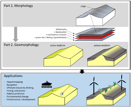
Seabed geomorphology exerts a first-order control on the distribution of marine ecosystems and geomorphology. Additionally, habitat maps provide foundational information for a broad range of marine applications. In 2019, the GeoHab meeting in St Petersburg hosted a seafloor geomorphology mapping workshop where participants were familiarised with a range of mapping tools (Dove et al., 2020a). One of these schemes (a collaboration between Mareano-Infomar-Maremap (Norwegian Geological Survey, GSI and the British Geological Survey)-Geoscience Australia: MIM-GA) advocated for standardised two-part classification of the seabed.
Part 1 (Morphology: Dove et al., 2020b) standardises the terminology that is used to classify the surface form of the seabed (i.e. from bathymetry datasets) through the provision of an illustrated glossary of features that enhance the terms defined within the International Hydrographic Organization guide for undersea feature names. The second step in this approach (Part 2: Geomorphology) has been drafted and similarly utilises well-established geomorphology classification schemes. These are used to assign a geomorphic origin to morphological features (Part 1: Morphology) based on other seabed and subsurface data and expert interpretation of formative processes. This second step provides key insights into the character and stability of seabed habitats and their distribution.
Together with researchers in MIM-GA, I am working on the draft of this Geomorphology glossary. In the following months, we are planning to invite the community to provide feedback on the draft of Part 2 via a public document to ensure that the approach is fit-for-purpose to provide foundational data for habitat mapping. A subsequent version of the scheme will reflect these inputs and form the basis of a workshop at the International Conference on Seafloor Landforms, Processes and Evolution (July 2022), where we have invited setting specialists (e.g. mass movement, coastal, fluvial geomorphologists) to provide final input to the scheme. If you can make it to the conference, I will see you there!
Ric
References
Dove, D., Bjarnadottir, L., Guinan, J., Le Bas, T., Nanson, R., Roche, M., Lecours, V., Stephens, D., Walbridge, S., Khadjinova, R., Di Stefano, M., Dolan, M., Debese, N., Jacq, J.J., Harris, P., Lamarche, G., Ryabchuk, D., 2020a. Seafloor Geomorphology (GeoHab Workshop); Key Resources and Future Challenges, GeoHab-2019 Conference, St. Petersburg. Zenodo, http://doi.org/10.5281/zenodo.3654320.
Dove, D., Nanson, R., Bjarnadóttir, L.R., Guinan, J., Gafeira, J., Post, A., Dolan, M.F.J., Stewart, H., Arosio, R. and Scott, G., 2020b. A two-part seabed geomorphology classification scheme:(v. 2). Part 1: morphology features a glossary. https://zenodo.org/record/4071940
Marine Geosciences Research Group
University College Cork
Contact us
School of Biological, Earth and Environmental Sciences, North Mall Campus, University College Cork, North Mall, Cork City, T23 TK30