In This Section
The Challenge
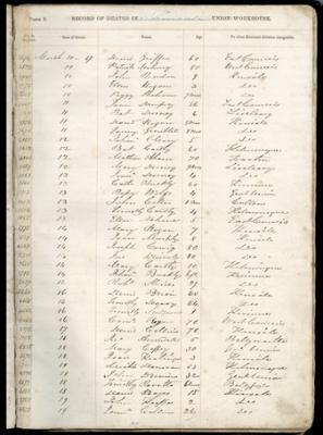
Fig. 1 Death Register, Kinsale Union Workhouse revealing the names of those who perished between 10th and 19th of March 1847 (Source: Cork City and County Archives)
The Great Irish Famine (1845-52) is probably the most pivotal event/experience in modern Irish history. Its global reach and implications cannot be underestimated. In terms of mortality, it is now widely accepted that a million people perished between the years 1845-52 and at least one and a quarter million fled the country, the great majority to North America, some to Australia and a significant minority (c. 0.3 million) to British cities. Why did a famine of this scale occur in a nineteenth-century European country, albeit a country subject to imperial rule? What place does it have as a shared national/international heritage? Many of those who perished are buried in mass Famine pits or in fields and ditches, with little or nothing to remind us of their going. A central challenge for researchers is to understand and remember where and why thousands and thousands of Irish people died.
The Research
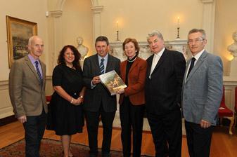
Fig. 2 Former President Mary Robinson at the launch of the Atlas of the Great Irish Famine (Cork University Press, 2012) at Newman House, Dublin 2012). It has sold over 20,000 copies
The generation and interpretation of c. 200 computer-based maps of population decline, social transformation and other key changes between the census years 1841 and 1851 is naturally the centre piece of the research. On the one hand, there are maps providing original, island-wide, almost panoptic views of the Famine. These allow us to see every parish from above but do not show how the Famine affected individual families and communities on the ground. In-depth parallel analysis of famine conditions in the provinces, counties, parishes and townlands – and in overseas emigrant destinations – seeks to tell the stories of particular individuals and families caught up in these terrible events.
What these maps document is a range of human worlds and conditions which are now an indispensable and invaluable contribution to Irish Famine studies. While recognising the power and effects of the general political and administrative forces at work and the devastating impacts of the Famine island-wide, the interpretation of these maps and other evidence equally highlights the diversity of local, county, provincial and emigrant conditions and experiences.
The Impact
Since its launch in Dublin in September 2012 by former President of Ireland Mary Robinson, the Atlas of the Great Irish Famine (Cork University Press and New York University Press) has been widely acclaimed both nationally and internationally and has been the winner of numerous awards including the Bord Gáis Best Irish-published book of 2012, the Best Irish book of 2012 as voted for by RTE Liveline listeners (Listenership 420,000) and the Geographical Society of Ireland book of the year in 2013.
The Atlas was officially launched by Professor Joe Lee in the Irish Consulate in New York in November 2012 and by novelist and essayist Thomas Keneally in the State Library of New South Wales, Sydney in August 2013. A leather-bound copy was also presented to President Barack Obama by the then Taoiseach Enda Kenny during the St Patrick’s Day celebrations in 2013. The Department of Arts, Heritage and the Gaeltacht presented a copy to city and county libraries nationwide in 2012, and the book was presented by CACSSS to each secondary school in the Munster region. A school’s exhibition and accompanying talk was organized by CACSSS and hosted by twelve schools in the Munster region
A book tour and exhibition was also organised by Cork University Press with over forty presentations delivered both nationally and internationally (including venues in London, New York, Chicago, Boston, Sydney, Melbourne, Perth). A panel discussion on the atlas including Thomas Keneally was also part of Listowel Writers’ week, June 2013.
A copy of the Atlas was presented to President Michael D. Higgins at Áras an Uachtaráin in November 2012 where the President acknowledged its significance:
‘The book represents a bringing home of the scholarship on the Famine, this particular volume is extraordinarily important, a great celebration of interdisciplinary work of the highest kind. It is just a wonderful book and provides a framework for the final breaking of all the silences that were there about the Famine...’
In March 2018 Taoiseach Leo Varadkar presented a copy of the atlas to Chief Garry Batton (47th chief of the Choctaw nation) in a ceremony in Durant, Oklahoma, to thank the Choctaw community for their donation towards famine relief in Ireland in 1847.
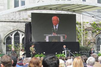
Fig. 3 President Higgins speaking at the National Famine Commemoration in UCC in May 2018 [Photo: John Crowley]
The maps which formed the centre-piece of the atlas are now part of the Great Famine online project, launched by Tánaiste Simon Coveney T.D. at the National Famine Commemoration held in UCC on 12 May 2018. This new digital resource is a major collaboration between the Department of Geography in UCC and the Department of Culture, Heritage and the Gaeltacht and will be an invaluable source of public history for current and future generations. Detailed information charting changes in the social, political and economic landscape of pre- and post-Famine Ireland is now available to users all over the world for the first time, through the App or by viewing the material online.
Speaking at the ceremony the Tánaiste said:
‘The development of the Great Irish Famine Online represents the culmination of work over a period of years and will represent a major resource for all students of the Great Famine. For the first time, people will be able to view and analyse information charting changes in the social, political and economic landscape of pre- and post-Famine Ireland.’
President Michael D. Higgins also spoke about the contribution of the research in his address at UCC in 2018
‘It is perhaps because its origins are steeped in such a history that University College Cork has been to the fore in bringing both a scholarly rigour and a moral engagement to the study of a defining period in what was, to use a phrase used by the late Brendan Bradshaw, the ‘catastrophic dimensions of the Irish past’. The Atlas of the Great Irish Famine, a project led by scholars of this university, represents an important achievement as a piece of inter-disciplinary scholarship and it is without doubt a profound contribution to our understanding of An Gorta Mór. We can all gain so much from drawing on the new research for a deeper understanding of the Great Famine, which was the single most important event in forming, and giving form, to a distinctive form of Irish modernity, one defined by catastrophe and its aftermath, by the determination to survive, whether at home or abroad, and by the drawing forth of some of the very best and worst instincts of humanity – greed and generosity, hope and despair, freedom and servitude. https://www.president.ie/en/media-library/speeches/address-at-the-national-famine-commemoration-2018
‘The Atlas of the Great Irish Famine is a stunning achievement, full of cutting-edge research and inter-disciplinary perspectives, lavishly illustrated and a worthy monument to the defining event in modern Irish history.’
Professor Diarmaid Ferriter, Department of Modern History, University College Dublin, The Irish Times 8 December 2012, p. 11
Conntacts
Dr John Crowley, Deparment of Geography.
Mr Mike Murphy, Department of Geography
Atlas Team
Dr John Crowley, Mr Mike Murphy, Professor Willie Smyth, Mr Charlie Roche, Department of Geography
College of Arts, Celtic Studies & Social Sciences
Coláiste na nEalaíon, an Léinn Cheiltigh agus na nEolaíochtaí Sóisialta
Contact us
College Office, Room G31 ,Ground Floor, Block B, O'Rahilly Building, UCC