In This Section
New research: habitat suitability models guide the reintroduction of Angolan giraffes
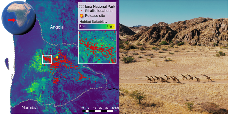
A new study shows how species distribution models combined with high-spatiotemporal-resolution satellite data can be extremely valuable for informing the translocations of animals.
The study, led by Dr Crego at BEES and in collaboration with researchers from the Giraffe Conservation Foundation (GCF), the Smithsonian‘s National Zoo and Conservation Biology Institute, and African Parks (AP), demonstrates that species distribution models (SDMs) can accurately predict the presence of good habitat in potential release sites to inform animal translocation programs.
Species distribution models are a set of statistical tools that link the known locations of organisms with environmental variables through advanced modelling techniques to predict areas of suitable habitats for such organisms. These models have been used in the past to aid animal translocations, but validating model predictions is rare due to the difficulties in tracking the fate of translocated individuals. In this new study, the team demonstrated that models can accurately predict adequate habitat using giraffe tracking data combined with high-spatiotemporal-resolution satellite imagery and machine learning. Results show that the reintroduced animals used areas that the model predicted as good habitat and avoided areas predicted as poor-quality habitat.
The study also shows that the translocation was successful, meaning that thanks to the work of GCF, AP, and the government of Angola, and after decades of being locally extinct, Angolan giraffes are back in the country.
The use of SDMs through the Google Earth Engine platform is something Dr Crego and collaborators have been working on for some time, allowing computationally demanding tasks to be performed for free using Google's powerful computing network. In a sense, it democratizes access to advanced ecological modelling techniques that can foster broader conservation impacts.
The study, together with the code published to facilitate the implementation of similar predictive models in other regions, contributes to the comprehensive toolkit required for successful animal reintroductions, streamlining the often-complex process of selecting a release site with data-driven decision making.
School of Biological, Earth and Environmental Sciences
An Scoil Eolaíochtaí Bitheolaíocha, Domhain agus Comhshaoil
Contact us
Distillery Fields, North Mall, University College Cork, Ireland , T23 TK30