2010 Press Releases
05.11.2010
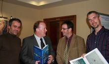
The Atlas of the Deep Water Seabed, Ireland, compiled in UCC by Dr Boris Dorschel and Dr Andy Wheeler, has been launched by Mr Conor Lenihan, Minister of State at the Department of Communications, Energy & Natural Resources.
The Atlas of the Deep Water Seabed, Ireland was unveiled on November 3rd 2010 at the Geoscience 2010 conference in Dublin Castle. The atlas was compiled by Dr Dorschel and Dr Wheeler, School of Biological, Earth & Environmental Sciences (BEES) and the Environmental Research Institute (ERI), UCC, from data gathered as part of the Irish National Seabed Survey (INSS) and INFOMAR inshore seabed survey undertaken by the Geological Survey of Ireland (GSI) the Marine Institute and partners.
Speaking at the launch, Minister Lenihan said: “This is the first such Atlas of its kind world-wide, reflecting our leading role in this field. It will be a valuable resource as we seek to utilise our vast ocean resources in the years ahead. As we develop ocean energy, offshore wind and further oil and gas prospecting, an accurate map of the deep seabed will be vital.”
Picture: Minister Conor Lenihan (second from left) with the authors of the atlas L-R: Xavier Monteys (GSI), Dr Andy Wheeler and Dr Boris Dorschel, UCC.

