2012 Press Releases
Atlas of the Great Irish Famine launched
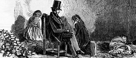
The Great Famine is possibly the most pivotal occurrence in modern Irish history. It is now widely accepted that over a million people perished between the years 1845-1852.
At least 1.25 million people fled the country, the great majority to North America, some to Australia and a significant minority (0.3 million) to British cities. Ireland had been afflicted by famine before the events of the 1840s; however the Great Famine is marked by both its absolute scale and its longevity.
It is also better remembered because it was the most recent and best-documented famine. This atlas, which is already being hailed as a book of the year, will engage and fascinate readers while providing them with a broad range of perspectives and relevant insights into this tragic event.
Why should a famine of this scale occur in a nineteenth-century European country, albeit a country under imperial rule? What was it like to live through this extraordinary, devastating time? While acknowledging the impossibility of addressing the Great Famine or any world famine, the Atlas attempts to bear witness to the thousands of people who died and are buried in mass famine pits or in fields and ditches. It seeks to achieve a greater understanding of the Famine, and its impact and its legacy.
How did people manage? Where did they go? The Atlas includes case studies of famine emigrants in cities such as Liverpool, Glasgow, New York and Toronto. The reality of the workhouse as a place of destitution is also examined in depth.
The Atlas is a stunning production. It includes 50 chapters with contributions from over 60 scholars who are experts in their fields – including the arts, folklore, geography, history, archaeology, cartography, Irish and English languages and literatures. It is a massive undertaking and has already received advance praise from all over the world.
There are 200 maps, many of which have been digitized in an ambitious project, which involved collating and digitizing maps of individual parishes and townlands, based on census records. This cartographic journey began almost 20 years ago and is now coming to fruition in this landmark publication.
Further information available from: http://corkuniversitypress.com/Atlas_of_the_Great_Irish_Famine_/357/