Research
ASU are currently involved in, and have also completed, several research projects funded by the European Union and government agencies.
IMAGIN: Irish Sea Marine Aggregates Initiative (2005 - 2007)
Background: Aggregates (sand and gravel) are essential products for the development and maintenance of infrastructure. Economically viable on-land sources in Britain and Ireland are rapidly diminishing, and alternative sources need to be found. In some areas of the UK the majority of aggregates used are already marine based. Significant marine aggregate deposits are available in the southern Irish Sea, and these can contribute to competitive regional development.
Research Goals: The aim of the IMAGIN project is to facilitate the evolution of a strategic framework within which development and exploitation of marine aggregate resources from the Irish Sea may be sustainably managed with minimum risk of impact on marine and coastal environments, ecosystems and other marine users.
Research Partners: IMAGIN brings together an Ireland/Wales scientific consortium comprising organisations with expertise in coastal processes, geology and marine resource management. ASU are involved in the identification and description of benthic communities in the Irish Sea and the development of a community wide sensitivity index. Overall management of the IMAGIN project is co-ordinated by the CMRC based in UCC. Further information on this research is available on the project's website or contacting the project manager, Mr. Gerry Sutton.

HIMOM: Hierarchical Monitoring Methods ...
HIMOM: Hierarchical Monitoring Methods (2002 - 2005) for Intertidal Flats
Background: Estuaries and intertidal sand or mud flats are coastal zone habitats whose functioning reflects changes in the coastal zone in general. These areas are one of the most productive natural ecosystems on Earth and changes to intertidal ecosystems greatly influence our natural environment. Active monitoring and management of these habitats is vital to the success of native and over-wintering bird populations and commercially important fisheries.
Research Goals: The overall objective of HIMOM was to provide a system of Hierarchical Monitoring Methods (HMM) to determine system change expressed by biological and physical variation within intertidal areas. The goal of HIMOM is then to implement the HMM and provide a management strategy tailored to the needs of selected end-users concerned with coastal zone management at sites around Europe.
Research Partners: The research group consisted of 8 partners from 5 European countries. It comprised of 5 academic institutes, 1 private company and 1 public authority that is responsible for coastal monitoring. ASU monitored the Fisherstown Flat along the Barrow Estuary in Co. Waterford. A suite of parameters was monitored for change by ASU personnel ranging from simple ground measurements of biota and physical characteristics to remote sensing of spectral reflectance properties for the analysis of basin scale systems.
Further information on this research is available on the Project's website >>
A CD information pack and further information on this project is available by contacting Derek Casey at the Aquatic Services Unit.
BIOPTIS: Intertidal Sediment Ecosystems ...
BIOPTIS: Intertidal Sediment Ecosystems A Remote Sensing Approach (1998 - 2001)
The BIOPTIS programme, which commenced early in 1998, addressed the use of remote sensing for the interpretation of intertidal systems and the assessment of environmental change. The BIOPTISproject maximised the discrimination of tidal flat characteristics by remote sensing and examined the importance of scale in actual measurements and modelled predictions of sediment processes. Links between pigment distribution, primary productivity and grazing in tide-influenced sediment systems were examined in detail. For more information on this project, please visit the BIOPTIS homepage.
For further information on this project contact Derek Casey at the Aquatic Services Unit.
Measurement and Modelling of Environmental Risk ...
Measurement and Modelling of Environmental Risk Associated with Phosphorus from Agricultural sources (2004 - present)
Summary:
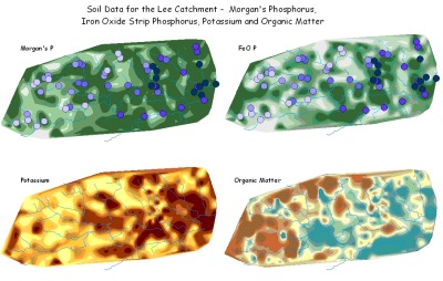
- A catchment-scale project looking at environmental risk of phosphorus loss from soil to water. Soil samples were taken on a grid network covering the entire catchment and analysed for phosphorus content and saturation. This was combined with a water sampling strategy, focusing on 56 sub catchments representing all land use and soil types throughout the catchment. The water quality sites were sampled 8 times over 2 years, during base and storm flow conditions, to produce a water quality map of the catchment.
- A phosphorus loss model is the final goal of the project incorporating precipitation and land use data, aimed at predicting stream phosphorus concentrations.
- Project Leader - Professor Ger Kiely, Department of Civil and Environmental Engineering, UCC.
- Figure showing Soil Phosphorus, Soil Potassium and Organic Matter for the Lee Catchment in addition to comparing water quality phosphorus (SRP mg/l) between storm and baseflows.

Funded by: Higher Education Authority - PRTLI3
Soil and Phosphorus 2000-LS-2.1.1-M1 (2001 - 2005)
Summary:
- The project studied the movement of phosphorus from soil to water in three separate nested catchments at a scale from 0.15 to 88km2. The three catchments were the Dripsey in Co. Cork, the Oona Water in Co. Tyrone and the Clarianna in Co. Tipperary. The Aquatic Services Unit was heavily involved in the Dripsey Catchment.
- In summary it was shown that fertilised Irish soils are a pathway for P transfer. Agricultural soils in rural catchments appear to be the largest contributor of P in freshwater. The extent of this transfer will depend on the level of fertilisation, with the higher the fertilisation, the higher the transfer. This is controlled among other things by soil type. Highly fertilised soils will transfer soluble or particulate P depending on the adsorptive capacity of the soil (soluble P) and the permeability of the soil (particulate P).
- Project Leader - Professor Ger Kiely, Department of Civil and Environmental Engineering, UCC.
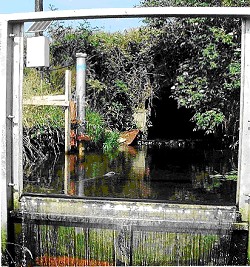
- Figure shows a stream gauging and sampling site.

Funded by: Environment Protection Agency (2000-LS-2.1.1-M1)
Real-Time Catchment Monitoring (2001 - 2004)
Summary:
- The project aim was to establish a water sampling network in the Douglas Catchment (Munster Blackwater), which could be accessed and controlled from the laboratory. The system providing high-resolution water quality data, which could be targeted to meet specific aims.
- The study catchment was mainly forested which led to installation problems which were overcome by developing new uses for existing technologies.
- A hydrological event-weighted sampling strategy was developed. This was used to develop a new model to predict phosphorus export, based on sparse water quality and precipitation data alone, and tested successfully against traditional estimation methods.
- Project Supervised - Gerard Morgan ASU, Professor John O'Halloran, BEES UCC, and Professor Paul Giller, BEES UCC. Research Technician - Stuart Warner ASU
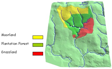
- Figure showing the land use in the study catchment.

Funded by: Higher Education Authority - PRTLI2
RUNTOX (Runoff Toxicology) (2001 - 2004)
Summary:
- This project investigated the effect of road runoff on freshwater ecosystems at a number of sites around Cork and Dublin.
- Runoff was sampled during rainfall events and analysed for heavy metals, PAHs (polyaromatic hydrocarbons) and nutrients. The stream sediment was analysed for the same parameters
- To quantify any biological effect, a survey of freshwater invertebrates up and downstream of runoff-input was undertaken
- The project supported evidence of other countries which suggested a localised effect, with little impact upon freshwater communities.
- This project was carried out by Sarah O'Reilly, Gearoid Webb and Selena O'Keefe, and supervised by Ger Morgan, Professor John O'Halloran (ZEPS UCC) and Professor Jim Heffron (Dept. Biochemistry UCC).
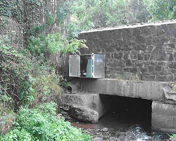
- Figure below shows the site setup, with the runoff-input and the automatic water sampler.

Funded by: Higher Education Authority - PRTLI2
Aquatic Services Unit
Contact us
Environmental Research Institute (UCC), Ellen Hutchins Building, Lee Road, Cork, Ireland T23 XE10
