Developing a tool to predict the distribution of seabirds
Project Overview
Seabird populations are protected under EU legislation and in the event of accidental oil pollution are very much in the spotlight. With the steadily growing fossil fuel industry in Ireland, and the obligation to protect its globally significant seabird populations, stakeholders need to ensure suitable management plans are in place and improved wherever possible. Seabirds breed on the coast where their population sizes are for many species reasonably well known. However they spend the majority of their life at sea, though exactly where is poorly known. This project combines state of the art GPS tracking with new modelling approaches to determine abundance and diversity hot-spots of seabirds along the Irish West Coast in a time- and cost-efficient manner.
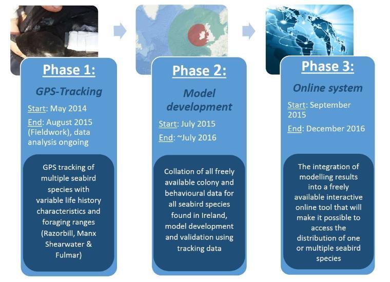
Fig. 1 - Phases of the project
People
- Professor John Quinn
- Saskia Wischnewski
- Emma Critchley
- Dr Mark Jessop
Phase 1: GPS-Tracking
GPS tracking of local seabirds is essential for the model validation process and improves the general understanding of their at-sea behaviour.
During the first field season in the summer of 2014, tracking and surveying of chick-rearing adult Razorbills, a short-ranging seabird, on Great Saltee, Co. Wexford showed consistent departure directions and foraging sites in a 60km radius around the colony (Fig.2).
In addition, tracking of 12 chick-rearing Manx Shearwater at two sites along the Irish West Coast (Great Blasket, Co. Kerry, and High Island, Co. Galway) revealed foraging trips up 3400 km to the Mid-Atlantic, 4 times longer than previously observed for this species, underlining the importance of local data for model validation. Other consistent foraging areas in Galway Bay and close to the Outer Hebrides, UK, could be identified (Fig. 3).
During the summer of 2015 a further 63 GPS tag were successfully deployed on the same species on both Islands. With about 200 individual tracks this compromises one of the biggest tracking data sets ever collected for a seabird species during one field season. The data is currently being analysed and prepared for publication.
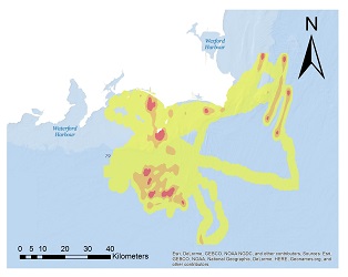
Figure 2: Kernel density estimation for tracked Razorbills (N=13)
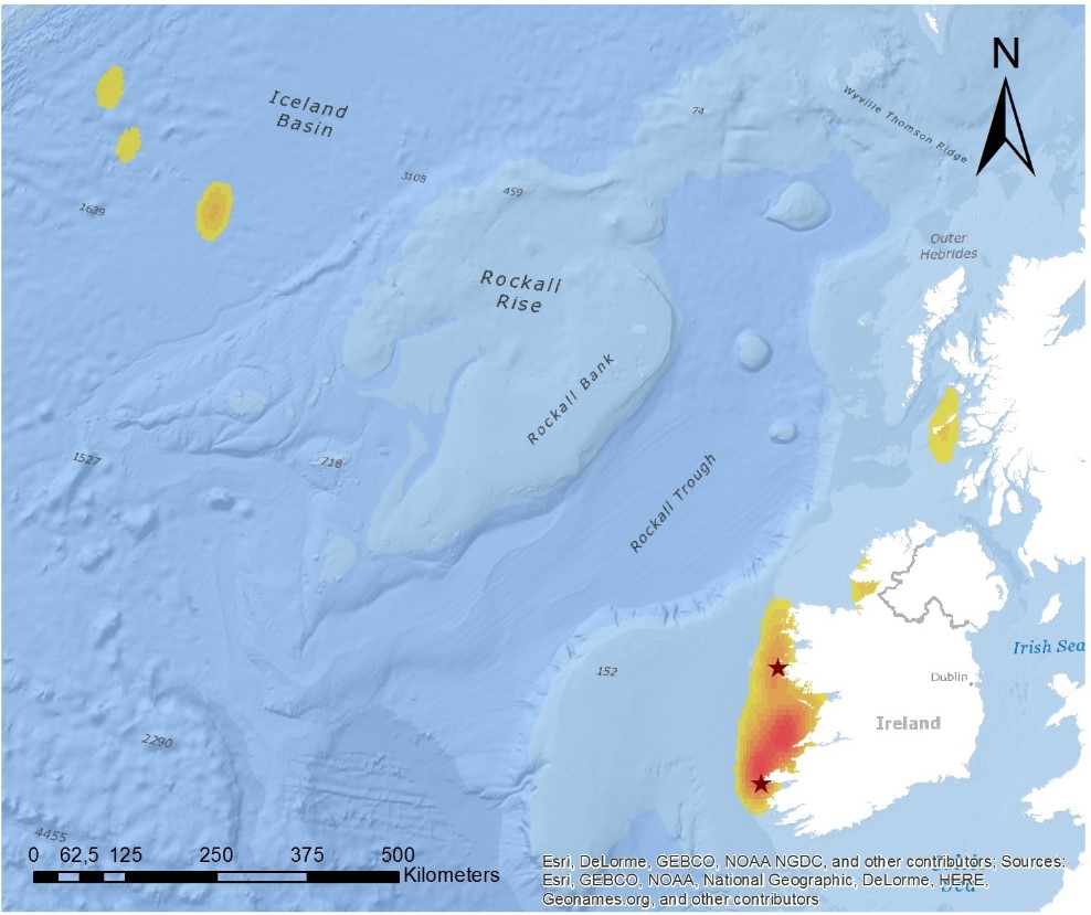
Figure 3: Kernel density estimation for Manx Shearwater tracked 2014. Stars indicate study sites. (N=12)
Phase 2: Database collation and model construction
A predictive distribution model is being developed that will produce maps showing both the extent and density of birds in 1km2 grid squares up to a distance of 400km from the colony. The model will be developed in stages, with greater complexity being added at each successive stage – incorporating data on colony locations, size and species foraging behaviour (Fig. 4). Predictive distribution maps will be produced for key seabird species found on the west coast of Ireland.

Figure 4: Schematic of model development process
Phase 3: Building an online system
The distribution maps produced from the model will be incorporated into an online GIS platform. From a drop-down menu users will be able to select whether to view distribution maps for an individual species or to overlay maps for all / groups of species, identifying areas with high densities of the most vulnerable species. It will be possible to group species according to foraging behaviour (e.g. surface feeders vs. divers) or conservation significance.
This project is funded by the Petroleum Infrastructure Programme (PIP), and has indirectly led to the funding of two parallel and complementary projects by Science Foundation Ireland and National Parks & Wildlife Services.